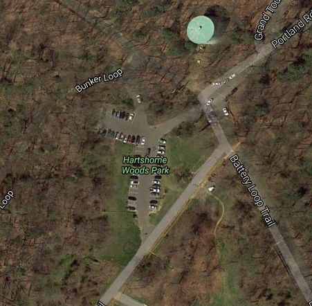
DIRECTIONS TO HENRY HUDSON (Hartshorne Trail Map Below- Battery Loop 1.5 mile course)- take Rumson Rd to 36 N to S. Bay Ave in Highlands. Take the Bay Ave exit on the Right from 36 N. This will take you under the bridge and then make a left onto Portland Rd. Stay on Portland Rd (you will be driving into Hartshorne Woods) until you reach a parking lot. We run the Battery Loop Trail. *You can park in the lot and we will meet on the open grass next to the lot
DIRECTIONS TO FORRESTDALE (RUMSON/FORRESTDALE)- Forrestdale runs at Meadowridge Park in Rumson. Meadowridge is across from Fair Haven Fields on Ridge Road just east of Red Bank Regional High School and Nativity Church.
DIRECTIONS TO FAIR HAVEN FIELDS (FAIR HAVEN/KNOLLWOOD)- Fair Haven runs at Fair Haven Field. Take Rumson Rd, Left on Hance, Right on Ridge Rd. Fields will be on your left (across from Meadowridge).
DIRECTIONS TO FAIR HAVEN FIELDS (FAIR HAVEN/KNOLLWOOD)- Fair Haven runs at Fair Haven Field. Take Rumson Rd, Left on Hance, Right on Ridge Rd. Fields will be on your left (across from Meadowridge).
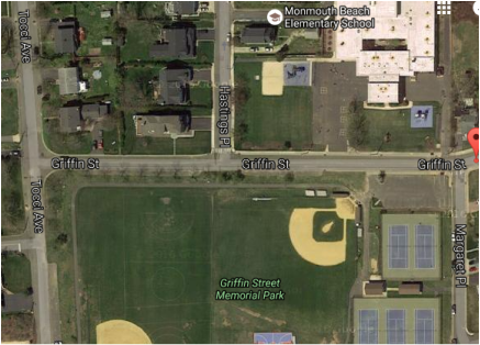
DIRECTIONS TO MONMOUTH BEACH ELEMENTARY SCHOOL-Take Seven Bridges Road over bridge into Oceanport-Turn left onto Monmouth Blvd and go over another bridge-Turn left onto Patten Ave and go over another bridge-Turn right onto Wesley Street-Turn right onto Tocci Ave-Turn left onto Griffin St-School Field is on your right (across from the elementary school- you can use 22 Griffin St as a GPS coordinate, parking is available on Tocci Ave and other neighboring streets). *The meet will start in the middle of the two baseball fields.
DIRECTIONS TO UNION BEACH - UNION BEACH MEMORIAL SCHOOL- 221 Morningside Ave. Union Beach, NJ 07735. Go North on Route 36 (Ocean Ave.) Go through Highlands, Atlantic Highlands, Leonardo, Belford and Keansburg. Make a right on Union Ave. Go down 4 blocks. Make a left on Morningside Ave. by the firehouse. Go down 1 mile. School is on the right side. *The course is behind the school, we will meet in the field next to the baseball field.
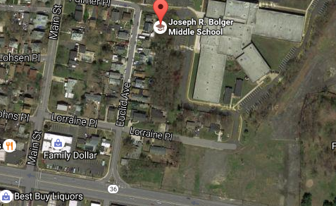
DIRECTIONS TO KEANSBURG - JOSEPH R. BOLGER MIDDLE SCHOOL- Take Rt. 36 North through Highlands and Atlantic Highlands, Middletown to Keansburg. Turn right on Main Street, Keansburg jug handle just before "Family Dollar". Go one block to Lorraine Place, make a right turn. Follow the Bolger Middle School driveway. (Parking is also available in the Shamrock Bus Company in the back of the school on the right hand side of Lorraine Place). *The meet will start behind the school.
DIRECTIONS TO HOLMDEL PARK (Ranney Meet- course map is found below, disregard 5k loop, our loop is 1.9 miles)- 44 Longstreet Rd- Take Newman Springs Road toward Holmdel. Follow Rte. 520 through Lincroft Center, pass Brookdale Community College, Thompson Park and CBA, make second right hand turn to Crawfords Corner-Everett Road. Stay on Crawfords Corner-Everett Road throughall the bends. You will eventually pass AT&T (Bell Labs)on the left. Make left turn atlight Longstreet Road (Holmdel High School on right). Follow sign for Holmdel Park--the Park is on the right.
Directions to Championship Meet at Bucks Mill Park, Bucks Mill Road, Colts Neck, NJ
COURSE MAP: http://coltsnecktrack.com/cougar%20inv/maps/2006_middle_map.htm
Directions: From the North: Garden State Parkway to Exit 117-A Aberdeen; continue turn right off of exit onto Lloyd Rd., at traffic intersection of Rt. 34 turn left going south, approximately 4 miles to Colts Neck. At 3rd traffic light turn right onto Rt. 537 (Colts Neck Inn on corner), after aprox. 1.5 miles sign for Hominy Hill Golf course on left; make right onto Bucks Mill Road - Park is aprox. 3 miles on left.
From the North/Rt. 34: Continue south, traffic light (Colts Neck In on corner, turn right onto Rt. 537 West, after arpxo. 1.5 miles sign for Hominy Hill Golf course on left; make right onto Bucks Mill Road - Park is aprox. 3 miles on left.
From the South: Garden State Parkway to Rt. 18 south; and/or Rt. 34 south; go past Delicious Orchards (on left) continue to traffic light (corner of Rt. 537, Colts Neck Inn on corner) turn left onto Rt. 537 west. After aprox. 1.5 miles sign for Hominy Hill Golf course on left; make right onto Bucks Mill Road - Park is aprox. 3 miles on left.
From the South/Rt. 34: Past Delicious Orchards, at traffic light turn, left onto Rt. 537 west(Colts Neck Inn on corner). After aprox. 1.5 miles sign for Hominy Hill Golf course on left; make right onto Bucks Mill Road - Park is aprox. 3 miles on left.
| holmdel_park_ms_xc.pdf |
| hartshorne09.pdf |